
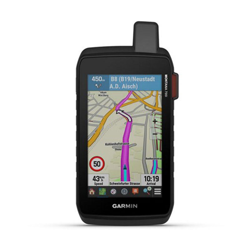
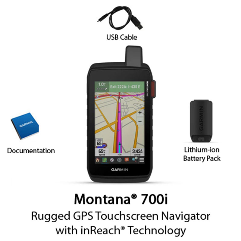

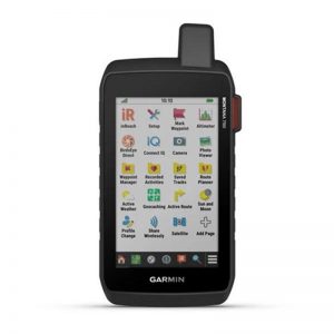
The Garmin Montana 700i has many exciting features for users of all types. It’s one of FactoryOutletStore’s best selling Garmin Handhelds & Wrist-Worn Navigators. You can extend the lifetime of your Garmin Montana 700i with the purchase of a FactoryOutletStore Factory Protection Plan. See the Garmin Montana 700i product video and gallery images above for more details. FactoryOutletStore stocks a full line of accessories like 4 GB microSD Card, AC Adapter Cable, and AC Adapter Cable Kit for the Garmin Montana 700i. The Garmin Montana 700i is sold as a Brand New Unopened Item.
| Physical dimensions | 3.6″ x 7.2″ x 1.3″ (9.19 x 18.30 x 3.27 cm) |
| Touchscreen | |
| Display Size | 2.55″W x 4.25″H (6.48 x 10.80 cm); 5″ diag (12.70 cm) |
| Display Resolution | 480 x 800 pixels |
| Display Type | WVGA transflective, dual orientation |
| Weight | 14.5 oz (410 g) with included lithium-ion battery pack |
| Battery Type | Rechargeable lithium-ion (included) |
| Battery Life | GPS Mode: up to 18 hours GPS Mode, 10 min Tracking: up to 18 hours Expedition Mode: up to 330 hours Expedition Mode, 30 min Tracking: up to 300 hours |
| Water Rating | IPX7 |
| MIL-STD-810 | Yes (thermal, shock, water, vibe) |
| High-Sensitivity Receiver | |
| Interface | High speed micro USB and NMEA 0183 compatible |
| Memory/History | 16 GB (user space varies based on included mapping) |
| MAPS & MEMORY | |
| Preloaded Maps | Yes (TopoActive, by region; Federal Public Lands maps, North America only; City Navigator®, by region) |
| Ability to Add Maps | |
| Basemap | |
| Automatic Routing ( Turn by Turn Routing on Roads) | Yes (with optional mapping for detailed roads) |
| Map Segments | 15000 |
| Birdseye | Yes (direct to device) |
| Includes Detailed Hybrographic Features ( Coastlines, Lake/River Shorelines, Wetlands and Perennial and Seasonal streams) | |
| Includes Searchable Points of Interests ( Parks, Campgrounds, Scenic Lookouts and Picnic Sites) | |
| Displays National,State and Local Parks, Forests, and Wilderness Areas | |
| External Memory Storage | yes (32 GB max microSD™ card) |
| Waypoints/Favorites/Locations | 10000 |
| Tracks | 250 |
| Track Log | 20000 points, 250 saved gpx tracks, 300 saved fit activities |
| Routes | 250, 250 points per route; 50 points auto routing |
| Rinex Logging | |
| SENSORS | |
| GPS | |
| Galileo | |
| Barometric Altimeter | |
| Compass | |
| GPS Compass (While Moving) | |
| DAILY SMART FEATURES | |
| Connect IQ™ ( Downloadable Watch Faces, Data Fields, Widgets and Apps) | |
| Weather | |
| Virb® Remote | |
| Pairs with Garmin Connect™ Mobile | |
| Active Weather | |
| Smart Notifications on Handheld | |
| SAFETY AND TRACKING FEATURES | |
| Livetrack | |
| OUTDOOR RECREATION | |
| Point-to-Point Navigation | |
| Compatible with Basecamp™ | |
| Area Calculation | |
| Hunt/Fish Calendar | |
| Sun and Moon Information | |
| Xero™ Locations | |
| Geocaching-Friendly | Yes (Geocache Live) |
| Custom Maps Compatible | Yes (500 custom map tiles) |
| Picture Viewer | |
| LED Beacon Flashlight | |
| INREACH® FEATURES | |
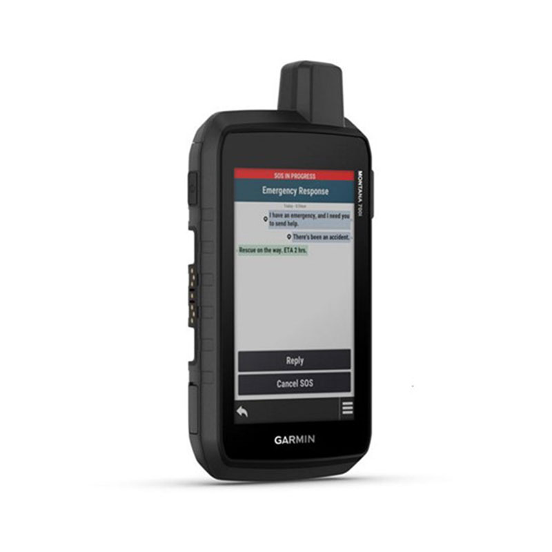
| Interactive SOS | |
| Send and Receive Text Messages to SMS and Email | |
| Send and Receive text messages to other Inreach Device | |
| Exchnage location with other inreach device | |
| Mapshare Compatible with Tracking | |
| Virtual Keyboard for custom messaging | |
| Send waypoints to mapshare during trip | |
| Send route selection to mapshare during trip | |
| Inreach Remote Compatible | |
| TWO-WAY RADIO FEATURES | |
| Contacts | |
| OUTDOOR APPLICATIONS | |
| Compatible with Garmin Explore™ APP | |
| Garmin Explore Website Compatible | |
| Dog Tracking | Yes (when paired to compatible dog track system) |
| CONNECTIONS | |
| Wireless Connectivity | Yes (Wi-Fi®, BLUETOOTH®, ANT+®) |

Reviews
There are no reviews yet.