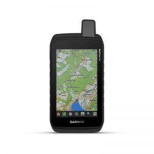
The Garmin GPSMAP 66sr may be small in size, but it packs a huge punch with the features it offers. Built with a sunlight viewable 3” color display that beautifully displays preloaded TopoActive maps for terrain contours, topographic elevations, summits, coastlines and geographical points within US & Canada. Quickly and easily download high-resolution photo-like maps directly to your GPSMAP 66sr with Birdseye Satellite Imagery now available without an annual subscription to help you locate parking, pick stand locations, and find trails all in the palm of your hand. This GPSMAP powerhouse is built to military standards for thermal, shock, and water performance (MIL-STD-810) and is even compatible with night vision goggles.
A built-in optional display of federal public land boundaries overlaid on topographical maps will aid in keeping you aware that you are venturing where you are supposed to be. Multi-Band technology along with expanded GNSS support (GPS, GLONASS, Galileo, QZSS, and IRNSS) satellite systems provide the upmost accuracy and reduced estimated position error when tracking you in urban canyons, forests with dense trees, and steep countryside. Your GPSMAP 66sr includes subscription free high-resolution photolike map downloads directly to your device to easily find trails, parking areas, and coastlines or rivers.
For adventures near or far, the GPSMAP 66sr can keep up with you throughout your journey with an internal lithium-ion battery that provides up to 36 hours of battery life in a GPS mode and up to 450 hours in an expedition mode while only taking approximately 6 hours to get a full charge. The included LED flashlight helps keep the gear that you carry to a minimum and can be also used as a beacon to signal for help! Navigate all of your trails with ABC sensors which include an altimeter for elevation data, a barometer to aid in monitoring weather, and a 3-axis electronic compass.


Reviews
There are no reviews yet.